

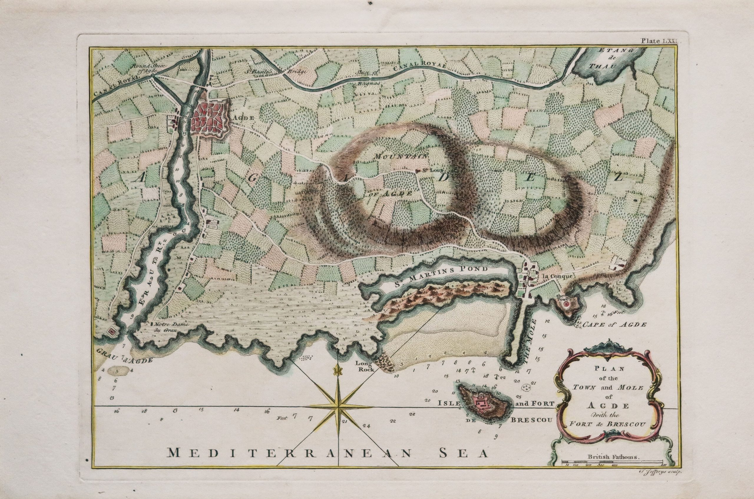
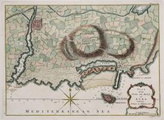
Carte marine ancienne d’Agde
250,00€
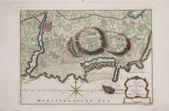
Plan of the town and mole of Agde with the Fort Brescou.
7th Chart of the coast of France from the Iles de Bretah to Port Louis.
Epreuve originale réalisée en 1759. J. Jefferys graveur.
Beaux coloris aquarelle.
Très bon état.
Format feuille : 36 x 24 cm.
Format gravure : 28,5 x 21 cm.
Original antique chart of 1759
1 en stock
DEMANDE D'INFORMATION
Thomas Jefferys (1695 – 20 novembre 1771) était l’un des éditeurs de cartes et graveurs les plus importants et les plus prolifiques de son époque.
Jefferys est né à Birmingham et a été apprenti chez le graveur Emmanuel Bowen en 1735. Plus tard, dans les années 1740, il a gravé plusieurs cartes pour le périodique populaire Gentleman’s Magazine.
Vers 1740, Jefferys put enfin se lancer en affaires et, en 1746, fut nommé « géographe de Fredrick, prince de Galles », qui peu après se traduisit par le poste de « cartographe royal du roi George III ». Jefferys s’est d’abord spécialisé dans la compilation et la regravure des œuvres des cartographes antérieurs dans des ensembles cartographiques plus cohérents. Plus tard, alors qu’il n’était pas salarié, la nomination de Jefferys en tant que « cartographe royal » garantissait un accès préférentiel au matériel cartographique le plus récent disponible, lui permettant de produire des cartes nouvelles et mises à jour d’une précision exceptionnelle. Il est surtout connu pour ses cartes des Amériques, en particulier l’Atlas américain publié à titre posthume en 1775, qui comprenait certaines des plus belles et des plus importantes cartes de l’époque coloniale tardive de l’Amérique jamais réalisées. Malgré son histoire prolifique dans l’édition, ses nominations royales et sa renommée internationale dans l’édition, Jefferys a vécu la majeure partie de sa vie dans une situation économique difficile.
Il a été renfloué de la faillite par Robert Sayer lors de la production de l’Atlas américain. En fin de compte, Jefferys est décédé subitement avec très peu à son nom. Néanmoins, son héritage cartographique a survécu, et même après sa mort en 1771, nombre de ses cartes importantes ont continué à être publiées et republiées par Sayer et Bennet, Conrad Lotter, Georges Louis Le Rouge, Laurie et Whittle, et d’autres. Beaucoup attribuent certaines des meilleures cartes de Jefferys au génie cartographique irlandais coloré et criminel Braddock Mead (John Green, vers 1688 – 1757), qui est considéré comme le « secret de Jefferys ». Jefferys a été remplacé par son fils, également Thomas, qui a eu peu de succès en tant que cartographe et s’est finalement associé avec, puis a vendu son stock et ses assiettes à William Faden – le véritable héritier de Jefferys.
William Faden (11 juillet 1749 – 21 mars 1836) était un cartographe et éditeur de cartes écossais de la fin du XVIIIe siècle. Faden est né à Londres. Son père, William MacFaden, était un imprimeur londonien bien connu et l’éditeur de The Literary Magazine. Pendant la rébellion jacobite (1745 – 1746), MacFaden a changé son nom de famille en Faden, pour éviter le sentiment anti-écossais. Faden a fait son apprentissage auprès du graveur James Wigley (1700 – 1782), obtenant sa liberté en 1771 – la même année que Thomas Jefferys Sr. est décédé.
Alors que Thomas Jefferys Sr. était un cartographe important et magistral, il était un terrible homme d’affaires et son fils, Jefferys Jr. avait peu d’intérêt à s’appuyer sur l’héritage de son père. MacFaden, reconnaissant peut-être une opportunité, a acquis pour son fils un partenariat dans la société Jefferys, qui s’est ensuite échangée sous le nom de « Faden and Jefferys ». Jefferys Jr. a également hérité du titre de Jefferys Sr., « géographe du roi et du prince de Galles ». Avec peu d’intérêt pour la cartographie ou l’édition de cartes, Jefferys Jr. a de plus en plus pris un siège arrière à Faden, se retirant complètement de la gestion quotidienne, tout en conservant son enjeu finical, en 1776.
La guerre d’indépendance américaine (1775 – 1783) s’est avérée être une période faste pour le jeune « géographe du roi », qui a tiré parti des documents existants et des cartes manuscrites inédites auxquelles il avait accès via sa nomination officielle, pour publier une multitude de cartes importantes, à la fois pour un usage officiel en temps de guerre et pour le public curieux. Cette période de prospérité a jeté les bases financières de Faden, qui en 1783, à la fin de la guerre, a acquis la pleine propriété de l’entreprise et a supprimé l’empreinte Jefferys. En 1801, il grave et publie les premières cartes pour l’Ordonance Survey britannique.
En 1822, Faden publie plus de 350 cartes, atlas et plans militaires. Il a pris sa retraite en 1823, vendant ses places à James Wyld Sr. Faden est décédé en 1836.
Produits similaires
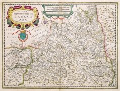
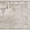
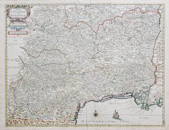
Languedoc & Roussillon
Languedoc Septentrional. Épreuve originale réalisée en 1638. J. Janson cartographe. Beaux coloris aquarelle. Infime rousseur dans la partie supérieure centrale. Très bon état. Format feuille : 53,5 x 45 cm. Format gravure : 51 x 38 cm. Original antique map of 1638
Languedoc & Roussillon
Épreuve originale gravée en 1785. Aveline graveur. Très bon état. Format feuille : 53,5 x 36 cm. Format gravure : 37 x 25 cm. Original antique engraving of 1785
Languedoc & Roussillon
Lithographie réalisée vers 1820/22. Engelmann lithographe. Infimes rousseurs dans les marges. Bon état. Format feuille : 32,5 x 23,5 cm Original antique lithography of 1820.
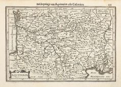
Aquitaine & Guyenne & Gascogne & Périgord
Épreuve originale gravée vers 1650. Jansson cartographe. Petite mouillure fine dans l'angle supérieure droit. Texte explicatif au verso en gothique. Bon état. Format feuille : 23,5 x 17,5 cm. Format gravure : 20,5 x 14 cm. Original antique map of 1650
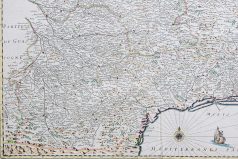
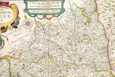
Languedoc & Roussillon
Épreuve originale gravée en 1634. Leclerc éditeur & Boisseau cartographe. Coloris aquarelle. Infimes traces de plis. Bon état. Format feuille : 59 x 44 cm. Format gravure : 53 x 41 cm. Original antique map of 1634. Bel exemple des premières éditions de cartes françaises, éditées à paris chez N. Bercy. Roses des vents.
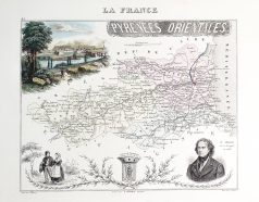
Languedoc & Roussillon
Épreuve originale gravée en 1874. Beaux cartouches aquarellé avec la ville de Perpignan. Très bon état. Format : 34,5 x 27 cm. Original antique map of 1874
Languedoc & Roussillon
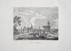
Épreuve originale gravée au 19ème siècle. Eugène Cicéri lithographe. Très bon état. Format feuille : 51 x 35,5 cm. Original antique lithography of the 19th century
Languedoc & Roussillon
Épreuve originale gravée au 19ème siècle. Wormser graveur. Beaux coloris aquarelle. Marge supérieure courte. Bon état. Format : 17,5 x 11 cm. Original antique engraving of the 19th century