

Plan ancien de New-York City – Original antique map
Plan original de 1893.
Très bon état.
Texte explicatif au verso.
Format feuille : 36 x 29,5 cm.
Original antique map of 1893
Vendu
DEMANDE D'INFORMATION
Produits similaires
Epreuve originale de 1797. Très bon état. Format feuille : 53,5 x 40,5 cm. Format gravure : 50 x 34,5 cm. Original antique map of 1797

Etats - Unis
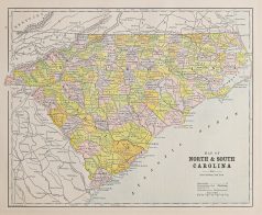
Plan original de 1893. Très bon état. Texte explicatif du Kentucky et Tennessee au verso. Format feuille : 36 x 29,5 cm. Original antique map of 1893
Etats - Unis
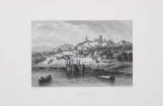
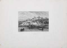
Epreuve originale gravée vers 1860. Willmann auteur. Très bon état. Format feuille : 38 x 27 cm. Format gravure : 20 x 15 cm. Original antique engraving around 1860
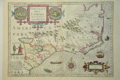
Carte originale de Hondius gravée en 1638. Double in -folio. Beaux coloris anciens. Infimes rousseurs dans le pli central. Format feuille : 54 x 44,5 cm. Format gravure : 50,5 x 36 cm. Texte explicatif en latin au verso. Original antique map of 1638
Carte originale gravée en 1870. Johnston cartographe. Belle impression en couleurs. très bon état. Format feuille : 61,5 x 48 cm. Original antique map of 1870
Etats - Unis
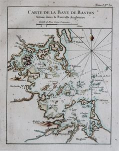
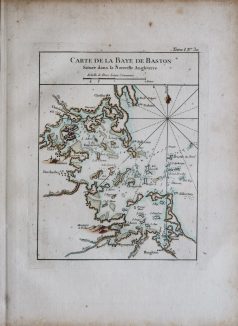
Epreuve originale réalisée en 1764. Bellin cartographe. Coloris aquarelle. Fines rousseurs éparses. Bon état. Format feuille : 33,5 x 24,5 cm. Format gravure : 23 x 18 cm. Original antique map of 1764. Carte particulièrement précise avec relevés des fonds marins, cartouche de titre aquarellé. Repère indiquant le nord.
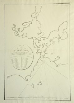
Plan ancien du Port de St François. Epreuve originale réalisée en 1797. Infimes rousseurs dans le pli central. Bon état. Format feuille : 53,5 x 40,5 cm. Format gravure : 48 x 32 cm. Original antique map of 1797. L'une des première représentation de la baie de San Francisco.
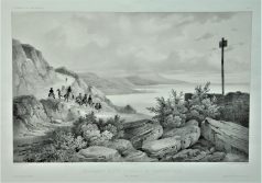
Lithographie originale de 1836. Dessinée par Lauvergne, chez Arthus Bertrand éditeur. Très bon état. Format feuille : 49 x 32 cm. Original antique engraving of 1836