
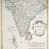
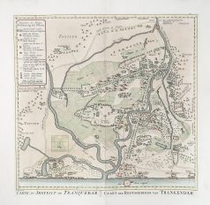
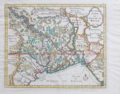
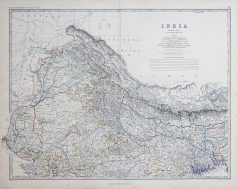
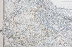
Carte géographique ancienne – Indes – Lecocq – Antique map
115,00€
Carte gravée sur acier en 1905 par Lecocq graveur.
Beau cartouche aquarellé.
Très bon état.
Format feuille : 42 x 28 cm.
Original antique map print in 1905.
1 en stock
DEMANDE D'INFORMATION
Produits similaires
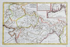
Inde & Pakistan
Carte originale gravée sur cuivre de 1753. Bellin cartographe. Très bon état. Coloris aquarelle. Format feuille : 38 x 36 cm. Format gravure : 31 x 31 cm. Original antique map of 1753
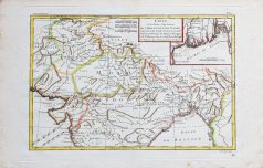
Inde & Pakistan
Carte de la partie supérieure de l’Inde en deçà du Gange. Epreuve originale réalisée en 1780. Rigobert Bonne cartographe. Beaux coloris aquarelle. Petites rousseurs éparses. Bon état. Format feuille : 41,5 x 27 cm. Format gravure : 34 x 23,5 cm. Original antique map of 1780
Inde & Pakistan
Carte originale gravée en 1750. Bellin cartographe. Beaux coloris aquarelle. Très bon état. Coloris aquarelle. Format feuille : 39,5 x 32 cm. Format gravure : 34 x 28 cm. Original antique map of 1750
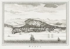

Inde & Pakistan
Original antique engraving – Dabul – Dabhol – Marathi : दाभोळ
Epreuve originale gravée vers 1750. J.V. Schley dessinateur. Infime petit trou de ver rebouché dans le centre de la côte. Bon état. Format feuille : 40,5 x 27 cm. Format gravure : 29 x 20 cm.
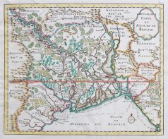
Inde & Pakistan
Carte gravée en 1750. Jacques-Nicolas Bellin cartographe. Coloris aquarelle. Cartouche décoratif. Excellent état. Format feuille : 38,5 x 28 cm. Format gravure : 32 x 23 cm. Original antique map of 1710
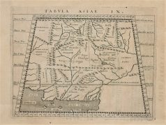
Afghanistan
Epreuve originale réalisée en 1590. Magini cartographe. Très bon état. Format gravure : 16,5 x 13,5 cm. Format feuille : 21 x 17,5 cm. Original antique map of 1590
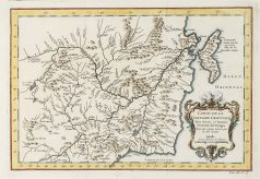
Inde & Pakistan
Carte originale gravée en 1863. Johnston cartographe. Belle impression en couleurs. Très bon état. Format feuille : 60 x 49,5 cm. Original antique map of 1863
Inde & Pakistan
Carte originale gravée sur cuivre vers 1750. Bellin cartographe. Petits trous anciens restaurés dans le nuage central supérieur. Bon état. Coloris aquarelle. Format feuille : 34,5 x 25 cm. Format gravure : 28,5 x 20,5 cm. Original antique map of 1750